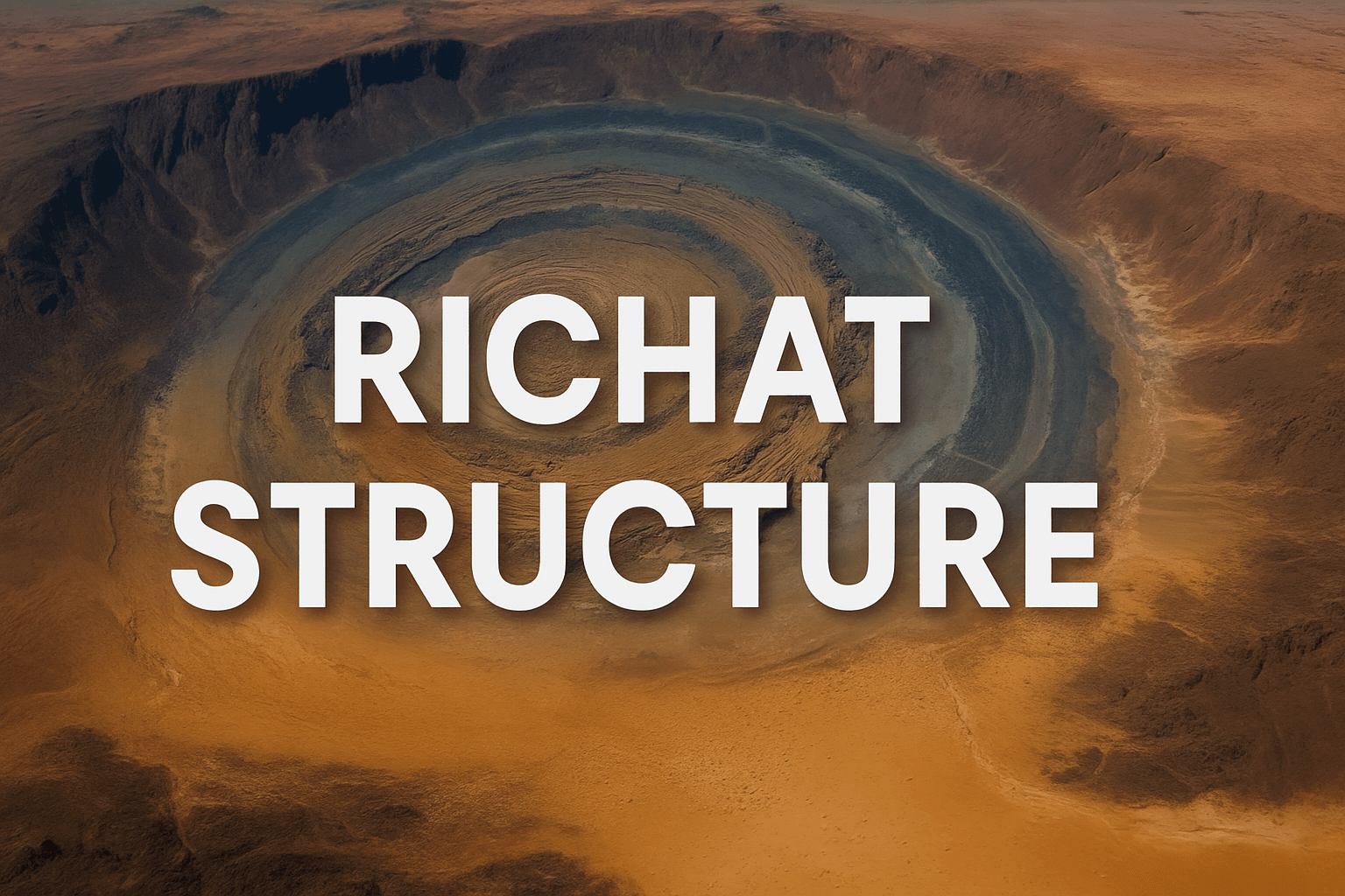
Deep within the Sahara Desert lies a mysterious geological formation known as the Richat Structure, or the Eye of the Sahara. Nearly 28 miles in diameter and perfectly circular from above, it has become a focal point in one of the most intriguing theories surrounding the legendary lost city of Atlantis.
For decades, scholars, fringe researchers, and curious minds have debated whether this remote structure could be the remains of a forgotten civilization described by Plato over 2,000 years ago. In this post, we will explore the Richat Structure in depth, analyze Plato’s writings, review supporting evidence and counterarguments, and consider whether the Eye of the Sahara could truly be the ancient city swallowed by the sea.
What Is the Richat Structure?
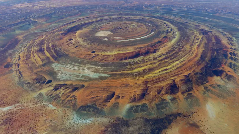
The Richat Structure is located near Ouadane, Mauritania, in northwestern Africa. From the ground, it appears as a vast eroded dome, with layers of sedimentary rock forming concentric circles. Its geological formation, originally thought to be an asteroid impact site, is now understood to be the result of symmetrical uplift and erosion over millions of years.
Key facts about the Richat Structure:
- Diameter: Approx. 45 km (28 miles)
- Age: Formed during the late Proterozoic (roughly 1 billion to 542 million years ago)
- Location: Sahara Desert, Mauritania
- Composition: Quartzite, volcanic rocks, and sedimentary layers
Despite its natural origins, the symmetry and scale of the Richat Structure continue to spark fascination, especially when compared to ancient descriptions of Atlantis.
Plato’s Atlantis: What Did He Say?
Plato, the Greek philosopher, introduced the world to Atlantis in two dialogues: Timaeus and Critias.

These texts describe a powerful island nation that existed around 9,000 years before Plato’s time and was said to have been destroyed in a single day and night of misfortune.
According to Plato, Atlantis:
- Was larger than Libya and Asia combined
- Had concentric rings of water and land
- Featured a central island with a temple to Poseidon
- Had fertile plains, mountains to the north, and rich natural resources
- Was located “beyond the Pillars of Hercules” (commonly interpreted as the Strait of Gibraltar)
- Was destroyed by a catastrophic event and sank into the sea
These details, while poetic and possibly allegorical, have fueled speculation for centuries.
Comparing the Richat Structure to Plato’s Atlantis
Let us examine how the Richat Structure aligns—or doesn’t—with Plato’s description:
| Plato’s Description | Richat Structure Observation |
|---|---|
| Concentric rings of land and water | The Richat has visible concentric geological layers |
| Central island | Elevated central plateau present |
| Mountains to the north | Mountain ranges lie to the north of the formation |
| Large fertile plain | Central Sahara was verdant during the African Humid Period |
| Located beyond the Pillars of Hercules | Located inland, but potentially fits if ancient coastlines shifted |
| Cataclysm ~9500 BCE | Timing aligns with the Younger Dryas cooling and global sea level rise |
These parallels form the backbone of the Richat-Atlantis hypothesis.
The Younger Dryas Impact Hypothesis
One of the most compelling elements linking the Richat Structure to Atlantis is the timing. Plato claimed Atlantis was destroyed roughly 9,000 years before his time, placing the catastrophe around 9500 BCE. This date coincides with the Younger Dryas, a sudden and dramatic climatic event that brought the Earth back into glacial conditions just as it was warming.
The Younger Dryas event:
- Lasted from about 12,900 to 11,700 years ago
- Saw abrupt global cooling
- Likely caused widespread flooding due to melting glaciers
- May have been triggered by a comet or asteroid impact (known as the Younger Dryas Impact Hypothesis)
The timing and potential environmental impacts of this event provide a plausible backdrop for a civilizational collapse.
Ancient Rivers and a Greener Sahara
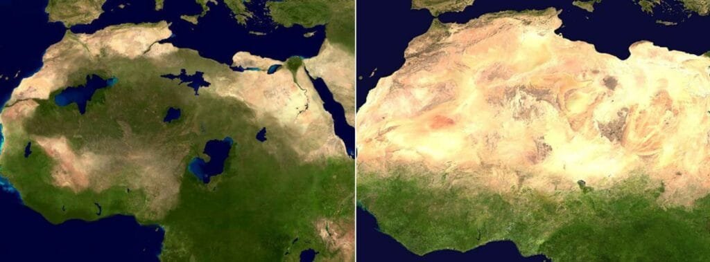
Today, the Sahara is one of the driest regions on Earth. But during the African Humid Period (roughly 11,000 to 5,000 years ago), the region supported:
- Lakes and rivers
- Forests and grasslands
- Human settlements
- Animal migration routes
Satellite imagery has revealed paleochannels—ancient, dried-up riverbeds—that once flowed near the Richat Structure. These could have connected the area to the Atlantic Ocean or large inland basins, supporting the idea that the region was once fertile and accessible by sea.
The Lack of Archaeological Evidence
A major challenge to the Richat-Atlantis theory is the absence of clear archaeological remains. No ruins, temples, or inscriptions have been found within or around the structure that indicate an advanced human civilization once lived there.
This raises several questions:
- Was any potential civilization built using biodegradable or perishable materials?
- Could erosion or shifting sands have hidden evidence?
- Have archaeologists properly investigated the site with this theory in mind?
Some fringe researchers argue that conventional archaeology has overlooked or dismissed anomalous findings due to academic bias.
Mainstream Scientific Perspective
Geologists overwhelmingly agree that the Richat Structure is a natural formation. Its circular shape, they argue, results from symmetrical uplift, erosion, and the exposure of different rock layers. There is no need for a human or mythological explanation.
Mainstream explanations emphasize:
- Sedimentary rock layers and volcanic activity
- No tools or artifacts typical of an ancient city
- No structural patterns indicative of city planning
From a scientific standpoint, the Richat Structure’s formation does not require Atlantis to exist.
Arguments Supporting the Theory
Despite mainstream skepticism, several points continue to attract Atlantis theorists:
- Geometric Alignment: The shape closely resembles Plato’s concentric description.
- Scale: The Richat’s size fits Plato’s estimated dimensions.
- Geological Timing: Plato’s timeline aligns with a known global climate catastrophe.
- Ancient Accessibility: During the African Humid Period, the Sahara was fertile.
- Mythological Resonance: Similar flood and collapse myths exist in cultures worldwide.
These arguments, while circumstantial, create a strong enough case to warrant further investigation.
Could the Richat Structure Have Been an Inspiration?
Another possibility is that Plato, or the Egyptian priests he references, had knowledge of the region’s geology or history—passed down through oral tradition or ancient observation. Plato may have combined factual knowledge of prehistoric Africa with philosophical allegory to create Atlantis as a symbolic warning about hubris, power, and natural disaster.
If true, the Richat Structure could represent a real place that inspired a myth—not necessarily Atlantis itself, but a forgotten city or civilization lost to time.
The Bigger Picture: Global Myths and Shared Memories
Across the globe, ancient cultures have passed down stories of massive floods, sunken cities, and golden ages lost in catastrophe:
- Sumerians wrote of a great flood in the Epic of Gilgamesh
- Indian texts describe the submersion of Dwarka, a city ruled by Lord Krishna
- Mesoamerican legends speak of lost lands and drowned kingdoms
- Biblical stories echo themes of divine punishment by water
Could these be fragmented memories of the same event—the Younger Dryas cataclysm?
Atlantis may not have been the only advanced culture to vanish. It may have been one of many, and the Richat Structure might hold a clue to understanding them.
Final Thoughts on the Richat Structure
The Richat Structure stands as one of the most fascinating geological features on Earth—and one of the most compelling candidates in the search for Atlantis.
It could be coincidence. It could be misinterpretation. Or it could be a piece of a much larger puzzle.
Until deeper archaeological work is done in the region, the mystery remains open. But one thing is certain: the Eye of the Sahara isn’t done watching us yet.
Pingback: The Lost City of Atlantis: Uncovering the Truth Behind the Mystery
Pingback: Plato’s Description of Atlantis: What Did He Really Say?